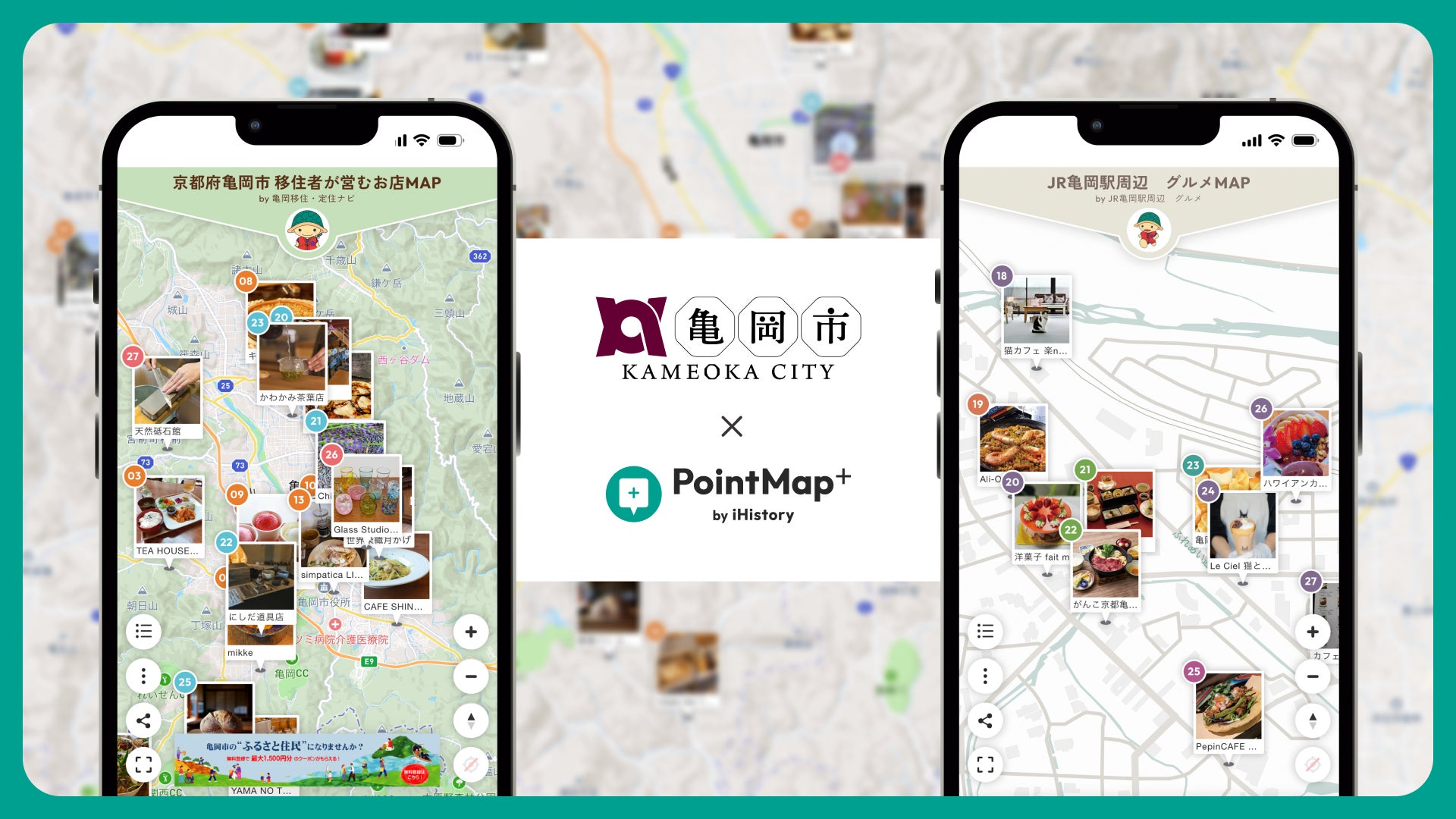
iHistory Inc. (Headquarters: Minato-ku, Tokyo; CEO: Issei Nakano) has created the digital maps 'Map of Shops Run by Migrants' and 'Restaurant Map around JR Kameoka Station' for Kameoka City, Kyoto, using its digital map creation service 'PointMap+'. Both maps have been published by Kameoka City.
For visitors to the '43rd National Urban Greenery Fair in Kyoto Tanba ~ Kyoto Tanba Midori no Sato Matsuri ~' held from Friday, September 18, 2026, to Sunday, November 8, 2026, the maps introduce shops run by migrants and restaurants around the station. They aim to create opportunities to experience the people and lifestyle of Kameoka by visiting local shops.
Map of Shops Run by Migrants: https://ihistory.site/pointmap/maps/kameokaiju
Restaurant Map around JR Kameoka Station: https://ihistory.site/pointmap/maps/kameoka-map
Kameoka City Press Release (September 15, 2026): https://prtimes.jp/main/html/rd/p/000000223.000052338.html
Combining 'Sightseeing' with 'Travel to Meet People'
Kameoka City aims to use this fair, which attracts visitors from across the country, to draw attention to the people and lifestyle of Kameoka. iHistory was responsible for creating the digital maps that serve as a catalyst.
PointMap+ is a platform that overlays photos and text on store locations, going beyond just guiding to places, and creating opportunities to walk through the city starting from 'the people there'. These two maps are examples of applying this concept to local government migration and tourism policies.
Map of Shops Run by Migrants
The digital map lists 27 shops (cafes, bakeries, workshops, guesthouses, etc.) run by owners who migrated to Kameoka City. To help visitors search according to their purpose, the shops are categorized with three colored pins corresponding to 'Eat, Buy, Experience'.
・Orange | Restaurants: Cafes, restaurants, and bakeries using local ingredients and unique touches
・Blue | Product and food sales: Food, specialty processed goods, etc.
・Pink | Experiences: Craft workshops at studios, stay-type bases, etc.
Each shop page includes photos taken by professional photographers, along with location, business hours, regular holidays, and official SNS links. Integrated with GPS, visitors can find nearby shops based on distance from their current location even while walking.
Restaurant Map around JR Kameoka Station: 46 Restaurants in Paper and Digital Formats for Meals Before and After the Fair
Near the fair venue, Kyoto Kameoka Hozugawa Park, the map lists 46 restaurants around JR Kameoka Station, categorized by genre (Japanese, Western, Izakaya, Bar, Cafe, Sweets). On each shop page, visitors can check business hours, regular holidays, and menu photos, and also search for nearby shops.
Some shops offer benefits when you show the map. Please check the paper map and each digital shop page for eligible shops and benefit details.
Additionally, 5,000 copies of an A3 foldable paper map have been produced and distributed at the fair venue and tourist information centers. By scanning the QR code on the paper, users can open the digital version and view detailed shop information and photos.
'Discover on paper, learn more on your smartphone.' The portability of paper is combined with the ease of updating digital information. Since the digital version can be updated after publication, it can accommodate changes in business hours during the fair period.
Features and Characteristics of PointMap+ Supporting Local Government Migration and Tourism Policies
The main features and characteristics used in creating these maps are as follows:
・No app required: Viewable from smartphone or PC browsers, no app installation needed for visitors.
・GPS integration: Find nearby shops based on distance from your current location.
・Shop information: Check business hours, regular holidays, photos, etc., on each shop page to help choose a shop.
・Color-coded pins by category: Makes it easier to find shops according to purpose, such as 'Eat, Buy, Experience'.
・Post-publication updates and continued use: Shop information can be updated after publication, and the map can be used as a regional information platform even after the event ends.
iHistory advocates 'MAP 3.0' as a new way of mapping that overlays human memories, sensibilities, and feelings on maps. In tourism and migration initiatives, we are advancing map creation that conveys the perspectives of the people living there, not just location guidance.
PointMap+ Service Page: https://www.ihistory.cloud/jp/pm/01/
What we want to deliver with PointMap+ is not just location information, but the thoughts and perspectives of the people there. We are confident that these digital maps will be an opportunity to encounter the people and lifestyle of Kameoka and want to visit again.
Future Developments
During the fair period, in addition to digital advertising, we plan to have micro-influencers with high interest in Kyoto Tanba lifestyle and gourmet food share their experiences of visiting shops using the maps.
After the fair, we will verify the effectiveness of the measures and compile recommendations for future migration policies.
iHistory Inc. will continue to collaborate with local governments and regions, and advance the creation of digital maps that create opportunities to experience local people and lifestyles.
Overview of the 43rd National Urban Greenery Fair in Kyoto Tanba
Name: 43rd National Urban Greenery Fair in Kyoto Tanba
Nickname: Kyoto Tanba Midori no Sato Matsuri
Period: Friday, September 18, 2026 – Sunday, November 8, 2026
Organizers: Kyoto Prefecture, Kameoka City, Nantan City, Kyotamba Town, Urban Greenery Foundation (Public Interest Incorporated Foundation)
Advocated by: Ministry of Land, Infrastructure, Transport and Tourism
Venue Area: Kyoto Tanba Region (Kameoka City, Nantan City, Kyotamba Town)
Official Website: https://kyototamba-fair.jp/
Maps Become Another Form of 'Self-Expression': 'Mapper Culture'
Maps are not just navigation tools; they can become 'personal media content' that conveys 'records', 'stories', and 'worldviews'.
Influencers and local governments called 'mappers' who create MAPs (maps) with a theme and share their unique perspectives and stories are appearing one after another. As a new information dissemination platform, 'mapper culture' centered on MAPs is gradually spreading.
iHistory Inc. will expand globally a culture where people connect through digital maps and enjoy life and living through 'PointMap+'.
What is the Digital Map Curation Media 'mapper world.'?
'mapper world.' is a digital map web media operated by iHistory, which selects and publishes MAPs publicly available on 'PointMap+' that excel in theme, composition, visuals, and perspective.
The published MAPs are edited based on each user's interests, experiences, and values, and are not just map information, but 'personal perspectives'.
FACT BOX
- Source: PR TIMES
- Category: News
- Products / services: PointMap+